Permits were organised and ended up costing $232.10 for a vehicle. This included the permit to transit through Arnhem Land although I wasn't allowed to stop there.
The NP people tell me that they do all the work of looking after the park but the traditional owners get 100% of the revenue from the permits.
I may be out of order here, but charging that much to visit a NATIONAL PARK seems pretty usurious to me. I thought that Nat Parks were resources for all Australians and should be available at some reasonable cost.
It is also interesting to note that revenues earned from any resource (whether from NP fees or mining royalties etc) are not considered as income if you identify as aboriginal or Torres Strait Islander and therefore are neither taxed nor affect the level of payment you get from CentreLink.
Yes, that is true, and where mining royalties can easily run into six figures (seven figures in a couple of cases) it doesn't seem even handed does it?
Whinge over.
I left home early and headed off to Kakadu. Cahill's Crossing (near Oenpelli) is the main route into Arnhem Land from this side and as it is tidal you need to make sure you don't want to cross within a couple of hours either side of high tide which is 5.5 hours after tide times at Darwin.
I filled up with fuel at Jabiru and headed for the Crossing.

It's nice to see signs like this isn't it?
The adventure begins.

On the road through to Oenpelli (and Ubirr etc) you need to cross the bridge over Magela Creek. This creek floods in the wet season and leave the normal flood wrack in the trees. As this year's wet was almost non-existent the flood levels were very low indeed and the evidence is in the trees there.
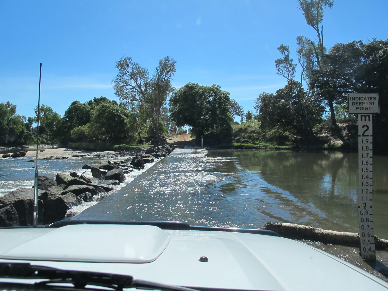
Cahill's Crossing. It is really not a drama for such a well known dangerous crossing. It is only dangerous if you try to do it around high tide. These days the rocks on the north side of the crossing will catch most vehicles if they get swept off the crossing, but you wouldn't want to rely on it would you?

Kakadu has large numbers of brumbies wandering around and all look fat and healthy like this one. The greenies want to remove them (and anything else that wasn't part of the environment back in 1770 including 4WDers), but the TOs are fond of them and won't allow it.
Paddocks like the one above are interspersed with wet land stretches and rock outcrops to form a beautiful and dramatic landscape that really makes you want to stop and breathe the air there and maybe take a few photos. Sadly the permit forbids us to do that.

The road continues beyond the beautiful spots around Oenpelli and the landscape turns into the typical northern Australian bush. Rather flat and feeling like it may be endless. The road itself becomes a corrugated exercise in tyre pressure adjustment, but every now and then you come across a feature that slows you down from the usual 85kph cruise. Sometimes it is a water crossing like the one above, but more often it is a washout or a bulldust hole - you REALLY need to keep your eyes open on this road to stay safe.
The corrugations ranged from the irritating (smoothed out once you get over 80kph) to the downright horrendous causing the Patrol to bang and shudder and rattle.

I said Phooey to the permit regulations and stopped at one point to get a cold water out of the fridge. Yes, it was water! and rest for a few minutes. The total concentration of driving this road takes its toll you know!
Anyway, this was a straight and relatively smooth section, but you can still make out the irritating corrugations.

Spot the dingo!
Wildlife was prolific on this trip, even during the day and I lost count of the number of dingoes I saw. I am pretty sure there won't be too many cats around here!

As you'd expect at this time of year, there were lots of fires burning, reducing the fuel load.

After a couple of hundred klms of rough road I eventually reached the Nat Park, but I still had 70 or 80 klms to travel to get to the camp sites.
Still, the trip had been done in perfect conditions (aside from the road) and I was feeling good. This was especially true as I hadn't seen another vehicle or human being since I left the Crossing.


I checked in with the ranger station and picked up some advice and info - really helpful people there - and drove off to the camp site. There are two sites, one that allows gennies and one that forbids them. As the individual sites in each case are close to a soccer pitch apart from each other and are screened by trees and shrubs I don't imagine the gennie site would have been noisy anyway, but I still chose the non-gennie site.
As you will see from the photos above, each site is pretty spectacularly set up with a shade, a nice picnic bench/table and a fireplace. The rangers told me to collect firewood from within the park (now THAT is something I have never come across before) as they didn't want to import any wood-borne pathogens into the park. There is, as he said, literally tons of firewood everywhere anyway.
Each site is also given a bin with a snug fitting lid and this bin is emptied every day by the rangers. Recycling bins for glass and aluminium cans are sited at the toilets.
In brief, the campsite was just perfect and every consideration has been made to your comfort. Just fantastic.


Regarding campers comfort, the toilets and showers are worth a mention. They are cleaned on a daily basis and are as nice to use as you could ever expect. No smells or spiders or litter or anything.
Also, if you have a look at the shower you will see two taps. That is because they provide (solar heated) hot water in the showers. Yes, HOT water. Just brilliant.


Across from the camp sites is the beach. This beach extends the whole way around the peninsula and is untouched. Of course, you can't go swimming here, but it does make for a beautiful scene.

This sign is no joke. To the right of the picture is the beach and to the left is a wetland area and crocs do cross the track here all the time. A couple of days later I stopped here to check out why someone else had stopped and they were looking at the foot prints and tail/belly drag marks of a huge croc. I can only relatively recently have crossed too as there were no tyre marks over them. These guys drove on before I could get my camera and destroyed the tracks, but believe me, they were impressive.

There are a couple of tracks to drive around this art of the park and the most scenic is the coastal drive which had me stopping every few minutes to gaze open-mouthed at the scenery. I was all alone out there and I loved it.
I also pulled out a rod with a few lures and flicked it around with no success.

At times the track cut slightly inland through tall grass paddocks and varied the scenery, but it was all good stuff.

After about 25 klms the track turned inland and became a fair bit more overgrown and rutted, but driving through the trees gave me an opportunity to see more dingoes and a couple of the Banteng cattle that run wild there.
The track eventually pops out on the main road back to the campsite. I had spent most of the day driving the track and walking on the beach so I headed back to cook dinner.

The next day I took a rutted track down to Caiman Creek to do some fishing. The photo above shows the steepest part of the track. Strange how photos make even the steepest and most washed out track look easy isn't it? Not that this was hard (at least in the dry) but it was the only place that I actually slipped the Patrol into low range.
The fishing was slow though. It must have been the wrong time of day or tide or barometric pressure or the lures were wrong or . . . . . . . . . .
I did hook two fish though. The first one I never saw and apart from a few slowish head shakes all it did was swim away unstoppably until the line broke. The second was (I think) a blue salmon that jumped and tail walked and thrashed about until it spat the lure.
Sigh - I will have to defrost a steak for dinner tonight then.

Caiman Creek hits the ocean here (see the photo above) and doesn't it look just gorgeous?

Across the water from the camp sites is the old Port Essington and the ruins of the Victoria Settlement. There is no road access so I couldn't get there, but at Smith Point the settlers built a beacon to warn ships away from the rocks and shoals just off the coast. The structure above is a memorial to them.
All too soon I had to head home to pick up Karen from the airport and to settle back into Darwin civilisation (which is a bit different to everywhere else).
The park had been spectacular and I would definitely head back there again - just beautiful - but the near 300 klms of corrugations back to Cahill's Crossing had to be re-conquered so off I headed.

The Crossing had one last surprise though - it was blocked by a tree trunk that had floated down the rived and settled across the causeway. We (me and half a dozen other vehicles) settled down to wait for the police to arrive.
The police eventually got there and commandeered a tourist truck/bus and drove out to the log. Two cops got out and tied a strap around the log and connected it to the front of the bus. There was a third cop armed with a rifle who sat in the bus and kept a lookout for crocs.

The bus slowly reversed back (fortunately it wasn't a Toyota bus as we all know about Toyotas and putting stress on their front diffs by reversing) dragging the log until it lay lengthways along the rock wall.
Yay! Let's hear it for the police!
So, Garig Nat Park - a great place. I am glad I went.