Sunday, April 27, 2014

The East Macs - An Easter Adventure

Yeah -we decided to take advantage of the three public holidays (Good Friday, Easter Monday and ANZAC Day) and took a two week break and travelled down to the East MacDonnells down in Central Australia.

An additional incentive was to catch up with our daughter Laura who lives in Alice Springs.

We were really lucky that the whole of Central Australia had received a whole heap of rain in the weeks leading up to our trip so the place was green and fresh and the cattle looked fat and healthy (and tasty!) as we travelled through.

The trip down to Alice is 1,500 klms so we decided to make it a three day trip south and headed off on the Saturday morning. The basic storyline is:-

Saturday 12th April
An easy day's drive - filling up with fuel in Katherine we carried on to the Daly Waters Pub and spent the night there.

Let me tell you, this pub could easily have become a spoof of a bush pub, but we had a hell of a good time with a great feed, cold drinks and fantastic entertainment and all for a reasonable price.

It is highly recommended.

Sunday 13th April
We trundled on for another few hundred kilometers, refuelling in Tennant Creek, and ending up - oh, is this getting to be a habit? - at another pub! This one is just south of the Devil's Marbles at a place called Wauchope. Another nice pub and also recommended.


This pic was taken over the fence and shows a flock of pigeons facing into the wind. Cute eh?

The Marbles were bypassed this time round - we were thirsty and the flies at the Marbles are usually pretty bad. Still, even just driving past them, they are an amazing sight.

Monday 14th April
Alice Springs - we arrived early enough and booked into the Big 4 van park there. Not just because we wanted a van park, but mostly because the town still seems to be a hotbed of petty theft and we just wanted to avoid the pain.

We caught up with Laura after she finished work and went out to the Outback Steakhouse for dinner. Rather a disappointment really with poor quality food and poor service. The fact that they have a selection of flags and will put one on your table representing your origins - we got one with the NT flag on it as we are from Darwin - does not really add anything to the experience.

Tuesday 15th April
After picking up supplies and Laura we headed off out along the Ross Highway and landed up at the Ross River Resort.


This place is a true diamond and I can't praise it enough. The camping area is clean and grassed (well, at least it is after the rain they have had) and we had lots of space to spread out in.

The homestead, with the hosts Jodie and Shane, is rustic but the bar/restaurant is big and spacious and once the get to know us they did things like tell us to help ourselves from behind the bar and just mark it up on a tab. How friendly is that? 


Camp fires were the order of each evening there, as was gazing off into the starry sky at night (and there were SO many stars!) waiting to catch a shooting star as it flicked across over our heads.

The camping ground has toilets and showers and is surrounded by bluffs like the one shown in the pic above. Check out the blue of the sky and the green of the grass! 

Wednesday 16th April


Now it should come as no real surprise to anyone that knows us to find that the Binns Track runs right alongside the camping ground and we were forced to take this route to get up to N'Dhala Gorge which was the first of the gorges we were planning on walking through. 

Now isn't this a sign that all 4WDers love to see ahead of them?  Heh heh heh. Follow this track to N'Dhala Gorge. 

We drove off to the gorge and parked up - what bliss to be the only people at a place like this! This was something that would be repeated time and again and we loved the solitude.

As you can see from these photos, the gorge holds water for some time after rain and as a result is an absolute haven for wildlife.

The cultural side of this place is that it holds a recorded 5,900 petroglyphs that date between 2,000 and 10,000 years old although dating petroglyphs is not easy. We found a few of them and (with the aid of the explanatory notes provided by the Parks Department) were able to follow some of the stories they portrayed.

Interesting stuff!

For the ignorati out there, a petroglyph is an image chipped into a rock surface.


Heading back to the camp site we gathered some firewood. I know that a roof rack increases fuel consumption through the additional drag, but it also makes a great platform for carrying wood! 

We gathered much of it from the dry parts of river beds but the bottom was firm and easy to drive on and there was plenty of wood to pick up. I have always said that you don't need a chainsaw if you can wield an axe (and I always carry an axe), but perhaps I am getting lazy as a chainsaw would indeed make the task a fair bit easier, especially when you are dealing with trees that have been washed down the river and are not a simple axing proposition.


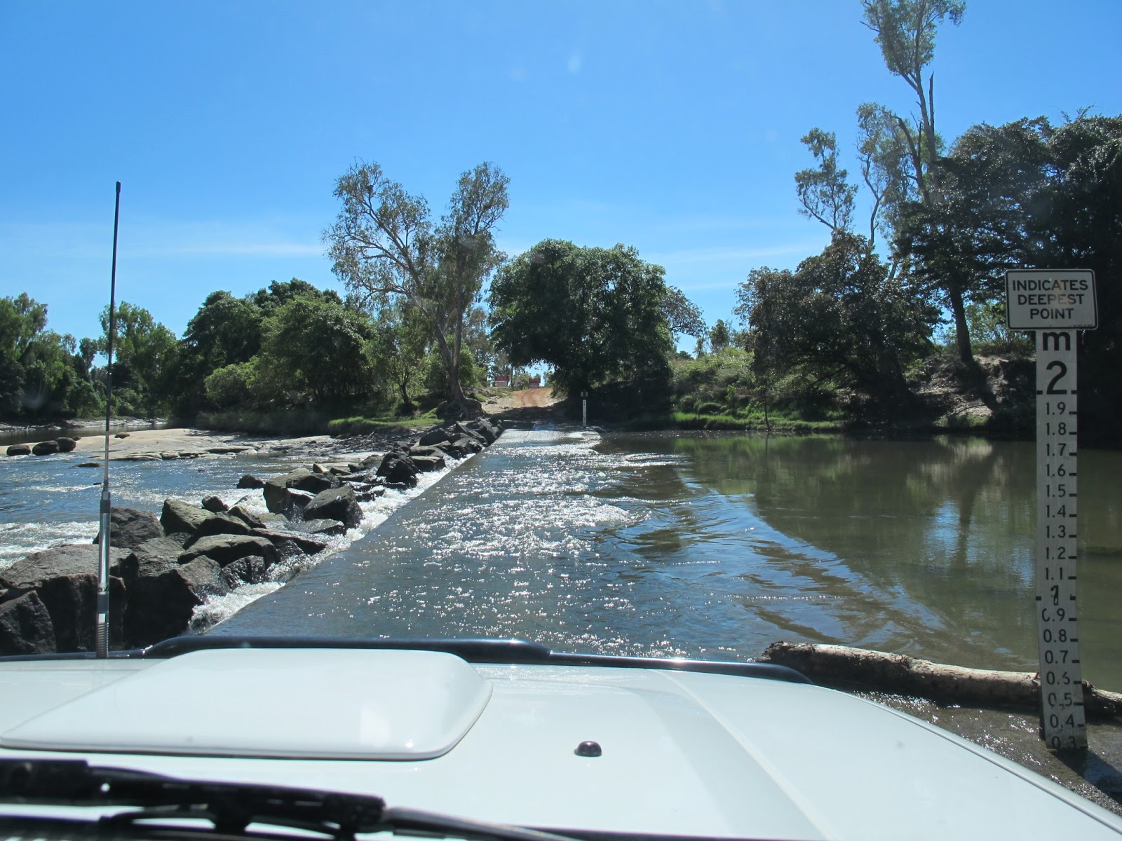
One thing I neglected to mention earlier is the fact that you need to cross the Ross River a number of times and the first three crossings held water.

This picture shows Laura driving across one of the crossings - she just loved doing it!  The water rose up to half way up the headlights at the deepest point (yeah - I missed it with the camera) so it generates some excitement and a test of the door seals, but it isn't a hard drive.


That night we had a clear sky with a perfect moon and a perfect camp fire. Gotta love a night like that! 


Thursday 17th April
Ruby Gap was the destination for the day and we set off fairly early as we were told it was a rough track into the place.

We bypassed Arltunga on the way in as we were keen to get into Ruby Gap and see what the place looked like and also to see if we could pick up any rubies (well garnets) from the sands there.

Well, as promised, the track was indeed rough and as an added attraction we found that the rain had cut quite a lot of deep channels and undercut the river banks we needed to climb as we drove through. Nothing that fazed the mighty Patrol but it slowed us down and made the ride uncomfortable.

Pics below show the countryside on the way in and some views of the gorge itself.

Once again we were the only people there - oh joy!


The pic above shows the track as it has descended to the river bed. Driving along this place was the only time we ever got close to bogging the Patrol as the coarse sand shifted all too readily under the wheels. 

We are facing one of the gorge walls here, having stopped for a bit of morning tea.  This pic, and the others below, struggle to convey just how majestic the whole place is. Some people don't like the feeling of being dwarfed by landscapes like this which is why the more human scaled gorges of the West Macs are so much more popular, but I love the feeling and the grandeur.

You just have to work a little harder to get to know the place.


Karen and Laura

Karen and me - I must do something about those man boobs though! 

I suppose I should show you a pic of the track in/out having said how rough it is. If you take a look at the trees either side you can see how steep the track is. Nothing challenging to drive, but you have to go slow. 

We had a late lunch at Arltunga and a wander around the information centre. We met a family of people who were just leaving the centre and heading off up the Binns Track and these were the only people we saw all day. Nice people too.

The info centre was a real mine of information, but there was nobody else there - no rangers or anything. 

We reached the home camp later that day and set up for a lamb roast in the camp oven. Could anyone possibly have a better day?


Friday 18th April
Well either too much grog was consumed last night or Laura really did have a head cold as she just wanted to stick around the camp and blow her nose all day.

Poos lass, she really did suffer with that cold.

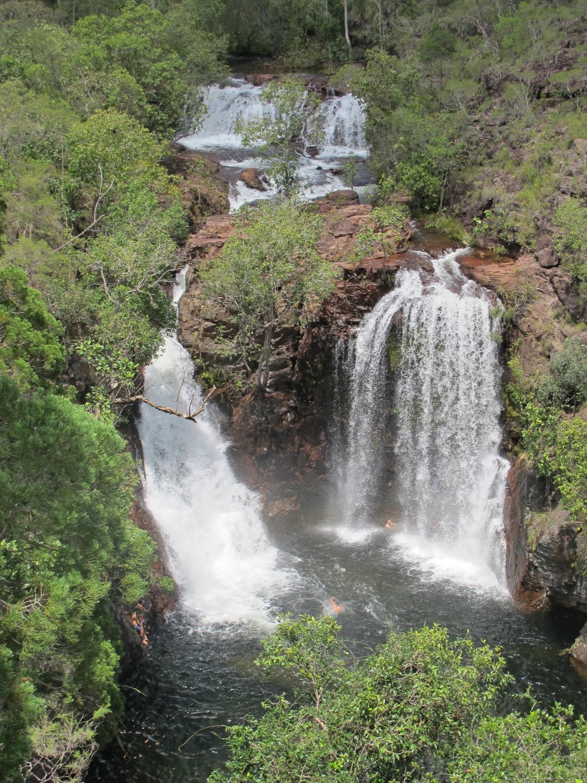
Anyway, that left Karen and me to head off to Trephina Gorge to explore the place and then take on the Panorama Walk.

Just before we got there though we followed a signpost to the "Ghost Gum". Now, ghost gums are not exactly rare out here, but this one is the biggest example found in the East Macs and it is spectacular. At 35 metres tall and 300+ years old it deserves a little respect.

These are beautiful trees and with their China white bark that is so cool to the touch and so glassy smooth they are amazing to be near. Love them.

The Panorama walk was excellent although we really should learn to set off on these walks in cooler hours of the day.

The initial climb is very steep and takes you up a goat track on the gorge wall before you pop out on the top and take in the view.

Magnificent isn't it?


As I said before, it was the hottest part of the day and we felt the heat. Got to love Karen's hat though!   :) 

The walk down from the rim was a much gentler affair and lead down to the river bed some way up the gorge. The walk back to the car was shady and level enough and very, very enjoyable.

Saturday 19th April
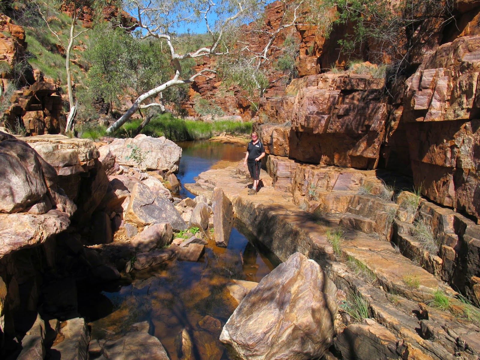
Today, Laura felt much better so we returned with her to Trephina Gorge and drove out to the John Hayes Rock Hole side of Trephina Gorge and did the Chain of Ponds Walk.

Once again we had to climb the steep sides of the gorge wall to get to the rim and we then walked around to the beginning of one of the gorge arms before descending down the gorge as it stepped down to the bottom of the main gorge.

Small ponds were to be found at each step down and were beautiful to see.

Check out the pics!

This one is of the John Hayes Rock Hole itself and it is found before you head off up the gorge wall. It isn't very pretty or remarkable, but it is important as it holds water for many months of the year.

Yep - this is my shadow and is my entry into the "Wanky Photo of the Year" competition.


Time for a rest! 


It is at this point that you get a surprise as the only way forward is to climb up the gorge wall (literally climbing up the cliff wall) to get to the top so you can walk around to the end.

Surprising, but fun. Of course, I wouldn't be saying that if I fell and broke a leg! 

And so, back to the car park where we pulled a beer out of the fridge and sat in the shade chatting and recovering before Laura drove us back out, testing her skills on the undercut creek banks. 


Sunday 20th April
This was a Nothing Day where we did nothing except rest and read and relax all day while Laura took the car into Alice to pick up a few supplies and to contact her boyfriend.

It's a dirty job, but . . . .

Monday 21st April
This morning was indulgent and lazy and we headed down to the homestead to watch the Footy as Geelong were playing Hawthorn.

A really good game to watch, the result went well for us too as we beat the Hawks by 19 points. Happy days.

We are Geelong, the greatest team of all!

Tuesday 22nd April
We packed the Patrol with tents and camping gear and headed off to see Chambers Pillar some 150 klms south of Alice.

The plan was to stay there the night and see what the Pillar looks like at dawn and dusk - it is such an icon that we couldn't miss the chance.

Then again, we missed the dawn view just through being rather lazy and sleeping in.

Anyway - the pictures tell the story . . . . .

Yep - it's a red dirt drive to get there.


This is our camp site at the Pillar. What more can I add? Well, I could tell you what was provided I suppose. As you can see, they provide fire pits (each one with a BBQ plate) at each camp spot as well as a few gas BBQs. You can see one just in front of the Patrol - they not only have a BBQ plate (stainless steel) but also two gas burners and they are free to use.

We brought our own wood in with us, but there is plenty to pick up on the way into the reserve.

There are a couple of long drop toilets which are pretty good for remote areas dunnies - no complaints there.

Oh yeah - we were the only people there until late in the afternoon when a convoy of six vehicles belonging to a 4WD club from Sydney rolled in. It was almost a shame really as it destroyed the solitude, but they were nice and friendly people so all was good.

The only other remarkable thing is that Laura wanted me to bake some damper so I knocked up some dough (self raising flour, salt and a can of beer) and baked what is the best damper I have ever managed to produce. A huge success!

During the day we did the walk up to the Pillar and around the base and checked out the graphitti.

Plants found all around the place and in beautiful flower!


There were some names or initials from 1870 too and there are supposed to be some from 1860 but we didn't see those. They are records of the early explorers who used the Pillar as a landmark and recorded their visits in this way. 

It is, of course, illegal to add to these marks these days.

The local indigenous people have an explanation for the landscape. Apparently there was a great warrior who, taking advantage of his fighting prowess, used to romance and cajole lots of the ladies into being his partner for the hight and bully the men into not interfering. Then one day the woman he took was from the wrong skin group and was a woman forbidden to him (presumably a close relative) but he ran away with her anyway and in running away he took the form of a giant gecko. When they stopped to lie down the spirits were offended and turned him into Chambers Pillar and the girl was turned into Castle Rock as punishment and a warning to all people to not mess with women forbidden to them! 

Castle Rock

The Pillar during the day

The Pillar as dusk approaches - the way it glows is uncanny.


Sunset! 

Wednesday 23rd April
We left the Pillar quite late in the morning, back down the track to the junction with the Finke road and drove off to see Lambert's Geographical Centre of Australia.

This involved driving south towards Finke along the old Ghan railway line. Much of the time this was simple enough as the old raised line bed is level enough (albeit corrugated in places) and straight enough to allow safe cruising at 60 to 80 kph. But then you come on a section where the line bed has washed away and you have to drive down  the washout slope, across the bottom and back up onto the line bed. Often this is not quite that simple if it is an old washout as you have to consider the trees and boulders and, as I have said before, the recent rains have left it more cut up than it would normally be.

The scenery was intriguing and natural with only the sun glinting off the occasional green can or the back bumper of a Commodore at the side of the track to spoil it.

Still, it adds entertainment to the drive which is long enough - some 150+klms and it was amazing just how many Commodore rear bumpers there were decorating the track - certainly more than there were wrecked cars (90% on their roof for some reason) which were also a regular enough sight.

Heading back out from Chambers Pillar - as you can see, I am in the passenger seat now. Yep, Laura wanted to drive!

She loved driving over the sand dunes (which are all capped with roadbase and are not a problem to drive over although a sand flag would be a good idea) and roller-coasting our way out.


Taken from the top of the steep ridge that you need to traverse on the way in and out. The picture does not show quite how steep it is, but for instance, Laura dropped it Troll into low range to make the drive up (and back down) easier. Yep - steep! 

Can you see Chambers Pillar on the horizon? 

Driving back down the other side of the ridge. You can just see where the track simply drops away.


It's a big, wide land isn't it?

You can see here how the rainwater has cut a channel in the track - you don't want to drop a wheel in there! 


Further down the track, and you can see how it has widened and leveled off as well as the corrugations forming, I spotted something in the distance - what is it?

Well, we got to drive (slowly) right next to this mystery and it was a feral camel. Magnificent beast looking fat and healthy (or is that "pregnant and healthy"?) and completely at home here. There are reputed to be over a million feral camels around central Australia - they certainly are comfortable.

This is typical of the old Ghan railway line - straight and easy with the major dangers being the occasional washout and the large number of old railway spikes left lying around. These things can rip a tyre to shreds very easily indeed.

The track runs next to the western edge of the Simpson Desert and the red dunes and spinifex are all along it.

This was one of the railway sidings found all long the track. Called Bundooma, it was one of the best preserved and a great spot for a rest.

We didn't take any photos of Finke itself, nor (and this surprised me) of the Finke race track that runs alongside the 4WD track for pretty much the whole way. Interesting to see though.

However, we eventually got to the Lambert's Geographical Centre of Australia, driving up the access track which turned into a maze of roughly parallel tracks, but they all seem to lead to the same place so you can't get lost.

The Centre has the obvious marker (see the pics below), but it also has some camping facilities including toilets that are amusingly labelled "Flick Dry" and "Drip Dry" instead of the usual Gents and Ladies.


Me at the middle

Karen at the middle.

Why is there a fire extinguisher mounted there?

Laura at the middle.

From this point we drove off to the Stuart Highway, pumped the tyres back up and headed for Ross river on the bitumen.

Thursday 24th April
Heading home today, with many happy memories and lots of regrets at leaving the Centre and the East Macs in particular. We have had a great time there and we have been very fortunate with the weather. The rain earlier left it green and beautiful and while we were there the days topping at 26 degrees and the nights at 13 degrees were just beaut.

We will be back, and when we do we hope Jodie and Shane are still running Ross River - they have been fantastic hosts.

The journey home was much the same as the trip down although we stopped at Wycliffe Well instead of at the Wauchope Hotel, just for a change.

The next night we stayed at Daly Waters again, but what a difference two weeks makes!

Two weeks ago the place was moderately patronised with maybe ten rigs in the camping grounds. This time it was jammed full and people were camping in the overflow area. Almost all of them being NSW and Victorian grey nomads all heading north to rape the rivers of cherubim and complain about the price of everything.

Still, that was our Easter trip this year and it was great.


Sunday, October 27, 2013

The Reynolds River Track - a one day excursion from Darwin.

This time, Karen was going to Alice Springs for work. She loves her job, even with the silly political posturing that is a part of any job that involves industry bodies and political control. Yeah - you get nutbags and office psychopaths everywhere. Still, that is all just window dressing and it doesn't actually affect things on a day to day working basis and she can continue to enjoy her work, and she loves the travelling that goes with it. This time she was staying over for a couple of nights to see our daughter, Laura, who has recently relocated to Alice.

So I grabbed the opportunity to head off down the Reynolds River Track to see what it is like at the end of the dry season and packed the Patrol with all the gear I thought I might need

  • Snatch straps (2) and rated shackles
  • Long handled shovel
  • Toilet shovel (just a small spade really)
  • MaxTrax
  • Radiator blind for those deep water crossings
  • The usual spares kit (hoses, belts, repair bits etc)
  • Swag, just in case I get caught out.
  • Fridge - only holds my lunch and a few bits of canned food in case I get stuck
  • Water - 4 litre "keg" and three 1 litre water bottles plus some tablets to clean up any river water I may need
  • Second spare tyre? Nah - I'll leave that at home and just take the tyre repair kit


This is always a welcome sight, especially as we have had a few storm cells blow through recently - I was worried that the track may have been closed due to localised flooding or wet track.

Airing down at the start of the track.

I dropped pressures to 24psi to give me a bigger footprint and better corrugation absorbence - I was going to need that!

Bear in mind that this is a hot pressure so it will equate to about 20psi cold pressures.

Looks good eh?  Places to go and things to see, can life get any better than this?


Now this looked nice! A simple creek across the track with a firm bottom and not too deep but it promises something more exciting along the way, The water itself was crystal clear and flowing very gently with some beautiful trees along its path.

Corrugations - uncomfortable and noisy, but they keep some people out so that is a good thing. The Parks people try to make us keep the speed down and protect the track by placing erosion mounds across the track every little while. They are like speed bumps on steroids and stop you travelling fast enough to iron out the corrugations. Unless you actually WANT to take off every couple of hundred meters that is!

They also trap water behind them so you always end up with a big muddy puddle to drive through.


The storm cell also brought down some trees and branches - I tried to drive to the Blyth Homestead but the track was blocked by this small tree across it that I just couldn't pick up and move - half the roots were still in the ground.

Wish I had a winch! I suppose I could have unshipped the axe and gone to town on it, but it was just too hot to engage in any physical work that I didn't absolutely have to. The Blyth Homestead will have to wait for another trip some day.

Termite mounds are everywhere! This is a Cathedral mound and they are all over the place - if you look closely you will see more of them in the trees in the rear of the picture.

Further down the track, on the flat plains area, the dominant termite mounds are the magnetic mounds and at the bottom are those mounds that look like nothing more than giant dog turds. The change in soil type and the local vegetation dictates the changes.


Glad I'm driving a Nissan! :)  It was almost a surprise to find that this was the only wrecked vehicle along the track - you get so used to finding wrecks almost everywhere you go around here and they are almost always Toyotas.

Of course, Toyotas actually form around 90% of the vehicles you'd see on the tracks so perhaps that isn't a surprise.

I kept driving along, checking out the occasional bird or small 'roo, and generally enjoying the drive and the scenery. The recent rains have not really affected the track but they have made everything green and pretty.

What a shame it is so hot! This far away from the ocean's effect it has been between 38 and 40 degrees all day and the humidity at about 80 odd percent is oppressive.

I took the turnoff to Tjaynera Falls and parked up and prepared for a walk to the falls themselves. At about 3.5 klms return it is not a long walk, but the track is not as easy as some. On top of that is the fact that in the valley the temperature and humidity seemed to soar so when I headed off and the sweat was dripping off my finger tips I knew it was going to be tough.

Pictures are below:

This is the Falls and the plunge pool and I had the place all to myself. What a beautiful place to be. The photo doesn't show the size of it, but that plunge pool is about 75 metres across and filled with fish.

I went for a swim (I NEEDED to cool down) and after splashing around the place I retrieved my hat and just sat in the water and chilled out.

The water was in three distinct layers with the top four inches being warmer than blood temperature, the next foot or so being warm and then below that was cool. It wasn't cold, just very, very pleasantly cool.

Sitting there I ended up being investigated by lots of fish including some decent sized sooty grunters.

Magic.

So, what does this display of clothes drying on a rock suggest to you?

Yep - they were sweat laden and needed drying while I went skinny dipping!


The last art of the track looked like this - all rocky and difficult to find firm footing,


Some of the track was just sandy like this.

And other parts needed you to be part mountain goat.

All in all, it was a beautiful lace and well worth shedding a couple of kilos of sweat to get there!

From that point on I drove through some grassy plains with the unusual magnetic termite mounds.

Edge on - you can see how thin they are. This example was about 8 or 9 feet tall.

This is the same mound from the side with the car door showing to give it some perspective.

As you can see, there are lots of them around and just look at how green that grass is!

Now, the really interesting part of this trip was the river crossing and I had a ball going through them.

The first crossing (the West one but I always think of it as the Northern one) I completely forgot to photograph because half way across I came across the first of only three vehicles that I saw on the track - yep - right in the middle of the river.

From the northern bank you drop into the river and drive downstream for about 40 metres before negotiating an island (about 40 square metres but it has lots of trees) and driving up onto a sand bank. That part of the crossing is made a little longer by the Parks people having roped off two thirds of the river to keep people out of a big hole and push them round the shallower part. The second part of the crossing is just to drive across to the far bank. Anyway, it was at this section that I met the car coming the other way resulting in some reversing up onto the sand bank and then a chat with the other driver.

Anyway, no photos I'm afraid, not even of the water washing up the bonnet!  Well, over the numberplate anyway. :)  Yeah - it was disappointingly shallow with the depth markers indicating that it was around 400mm deep for most of the river. Still, it is always exciting driving along a creek, especially when you see the croc warning signs at the entrance to it - will I see one or won't I? The answer is no, I didn't see one.

The second crossing (see below) was not even worth mentioning.


Yeah - disappointing isn't it?

So I trundled on, just checking things out until I got to the turn off for Surprise Creek falls where there was a Nissan Pathfinder parked in the parking area.

The walk to the falls was a short one, although very sandy, and I got to the falls after about five minutes where I found a family of four people enjoying the water.


This plunge pool is not only more open than Tjaynera, it is also the beneficiary of a much more gentle slope of the ground so it is much safer for kids - there really is a shallow end unlike Tjaynera where the water drops off into the VERY deep within a metre or so.

Anyway, I didn't think the family would appreciate me stripping off and joining them so I left them to their swim and headed off again.

From that point on the drive was easy with some water holes before heading off to the Adelaide River pub for a couple of cleansing ales and a welcome burger before going home.

Reynolds River Track? A pleasant day trip out of Darwin, but it isn't the dramatic challenge that some accounts make it to be. Of course, on another day and with more water around it would be, so perhaps I can get back here then.

Thanks for reading this.

Tuesday, June 18, 2013

Garig Gunak Barlu - The Cobourg Peninsula

Karen was heading off to Melbourne for a conference so I had a few days spare and decided to head out to the Cobourg Peninsula to see what the place was like. I had heard so many good reports about it that it had been on the To Do list for some time.

Permits were organised and ended up costing $232.10 for a vehicle. This included the permit to transit through Arnhem Land although I wasn't allowed to stop there.

The NP people tell me that they do all the work of looking after the park but the traditional owners get 100% of the revenue from the permits.

I may be out of order here, but charging that much to visit a NATIONAL PARK seems pretty usurious to me. I thought that Nat Parks were resources for all Australians and should be available at some reasonable cost.

It is also interesting to note that revenues earned from any resource (whether from NP fees or mining royalties etc) are not considered as income if you identify as aboriginal or Torres Strait Islander and therefore are neither taxed nor affect the level of payment you get from CentreLink.

Yes, that is true, and where mining royalties can easily run into six figures (seven figures in a couple of cases) it doesn't seem even handed does it?

Whinge over.

I left home early and headed off to Kakadu. Cahill's Crossing (near Oenpelli) is the main route into Arnhem Land from this side and as it is tidal you need to make sure you don't want to cross within a couple of hours either side of high tide which is 5.5 hours after tide times at Darwin.

I filled up with fuel at Jabiru and headed for the Crossing.


It's nice to see signs like this isn't it?

The adventure begins.


On the road through to Oenpelli (and Ubirr etc) you need to cross the bridge over Magela Creek. This creek floods in the wet season and leave the normal flood wrack in the trees. As this year's wet was almost non-existent the flood levels were very low indeed and the evidence is in the trees there.


Cahill's Crossing. It is really not a drama for such a well known dangerous crossing. It is only dangerous if you try to do it around high tide. These days the rocks on the north side of the crossing will catch most vehicles if they get swept off the crossing, but you wouldn't want to rely on it would you?


Kakadu has large numbers of brumbies wandering around and all look fat and healthy like this one. The greenies want to remove them (and anything else that wasn't part of the environment back in 1770 including 4WDers), but the TOs are fond of them and won't allow it.

Paddocks like the one above are interspersed with wet land stretches and rock outcrops to form a beautiful and dramatic landscape that really makes you want to stop and breathe the air there and maybe take a few photos. Sadly the permit forbids us to do that.


The road continues beyond the beautiful spots around Oenpelli and the landscape turns into the typical northern Australian bush. Rather flat and feeling like it may be endless. The road itself becomes a corrugated exercise in tyre pressure adjustment, but every now and then you come across a feature that slows you down from the usual 85kph cruise. Sometimes it is a water crossing like the one above, but more often it is a washout or a bulldust hole - you REALLY need to keep your eyes open on this road to stay safe.

The corrugations ranged from the irritating (smoothed out once you get over 80kph) to the downright horrendous causing the Patrol to bang and shudder and rattle.


I said Phooey to the permit regulations and stopped at one point to get a cold water out of the fridge. Yes, it was water! and rest for a few minutes. The total concentration of driving this road takes its toll you know!

Anyway, this was a straight and relatively smooth section, but you can still make out the irritating corrugations.


Spot the dingo!

Wildlife was prolific on this trip, even during the day and I lost count of the number of dingoes I saw. I am pretty sure there won't be too many cats around here!


As you'd expect at this time of year, there were lots of fires burning, reducing the fuel load.


After a couple of hundred klms of rough road I eventually reached the Nat Park, but I still had 70 or 80 klms to travel to get to the camp sites.

Still, the trip had been done in perfect conditions (aside from the road) and I was feeling good. This was especially true as I hadn't seen another vehicle or human being since I left the Crossing.


I checked in with the ranger station and picked up some advice and info - really helpful people there - and drove off to the camp site. There are two sites, one that allows gennies and one that forbids them. As the individual sites in each case are close to a soccer pitch apart from each other and are screened by trees and shrubs I don't imagine the gennie site would have been noisy anyway, but I still chose the non-gennie site.

As you will see from the photos above, each site is pretty spectacularly set up with a shade, a nice picnic bench/table and a fireplace. The rangers told me to collect firewood from within the park (now THAT is something I have never come across before) as they didn't want to import any wood-borne pathogens into the park. There is, as he said, literally tons of firewood everywhere anyway.

Each site is also given a bin with a snug fitting lid and this bin is emptied every day by the rangers. Recycling bins for glass and aluminium cans are sited at the toilets.

In brief, the campsite was just perfect and every consideration has been made to your comfort. Just fantastic.


Regarding campers comfort, the toilets and showers are worth a mention. They are cleaned on a daily basis and are as nice to use as you could ever expect. No smells or spiders or litter or anything.

Also, if you have a look at the shower you will see two taps. That is because they provide (solar heated) hot water in the showers. Yes, HOT water. Just brilliant.


Across from the camp sites is the beach. This beach extends the whole way around the peninsula and is untouched. Of course, you can't go swimming here, but it does make for a beautiful scene.


This sign is no joke. To the right of the picture is the beach and to the left is a wetland area and crocs do cross the track here all the time. A couple of days later I stopped here to check out why someone else had stopped and they were looking at the foot prints and tail/belly drag marks of a huge croc. I can only relatively recently have crossed too as there were no tyre marks over them. These guys drove on before I could get my camera and destroyed the tracks, but believe me, they were impressive.


There are a couple of tracks to drive around this art of the park and the most scenic is the coastal drive which had me stopping every few minutes to gaze open-mouthed at the scenery. I was all alone out there and I loved it.

I also pulled out a rod with a few lures and flicked it around with no success.


At times the track cut slightly inland through tall grass paddocks and varied the scenery, but it was all good stuff.


After about 25 klms the track turned inland and became a fair bit more overgrown and rutted, but driving through the trees gave me an opportunity to see more dingoes and a couple of the Banteng cattle that run wild there.

The track eventually pops out on the main road back to the campsite. I had spent most of the day driving the track and walking on the beach so I headed back to cook dinner.


The next day I took a rutted track down to Caiman Creek to do some fishing. The photo above shows the steepest part of the track. Strange how photos make even the steepest and most washed out track look easy isn't it? Not that this was hard (at least in the dry) but it was the only place that I actually slipped the Patrol into low range.

The fishing was slow though. It must have been the wrong time of day or tide or barometric pressure or the lures were wrong or . . . . . . . . . .

I did hook two fish though. The first one I never saw and apart from a few slowish head shakes all it did was swim away unstoppably until the line broke. The second was (I think) a blue salmon that jumped and tail walked and thrashed about until it spat the lure.

Sigh - I will have to defrost a steak for dinner tonight then.


Caiman Creek hits the ocean here (see the photo above) and doesn't it look just gorgeous?


Across the water from the camp sites is the old Port Essington and the ruins of the Victoria Settlement. There is no road access so I couldn't get there, but at Smith Point the settlers built a beacon to warn ships away from the rocks and shoals just off the coast. The structure above is a memorial to them.

All too soon I had to head home to pick up Karen from the airport and to settle back into Darwin civilisation (which is a bit different to everywhere else).

The park had been spectacular and I would definitely head back there again - just beautiful - but the near 300 klms of corrugations back to Cahill's Crossing had to be re-conquered so off I headed.


The Crossing had one last surprise though - it was blocked by a tree trunk that had floated down the rived and settled across the causeway. We (me and half a dozen other vehicles) settled down to wait for the police to arrive.

The police eventually got there and commandeered a tourist truck/bus and drove out to the log. Two cops got out and tied a strap around the log and connected it to the front of the bus. There was a third cop armed with a rifle who sat in the bus and kept a lookout for crocs.


The bus slowly reversed back (fortunately it wasn't a Toyota bus as we all know about Toyotas and putting stress on their front diffs by reversing) dragging the log until it lay lengthways along the rock wall.

Yay!  Let's hear it for the police!

So, Garig Nat Park - a great place. I am glad I went.

Tuesday, March 19, 2013

Litchfield

After discovering that the Patrol had some water in its diesel (probably just the condensation from the humid atmosphere here) I chucked in a bottle of some magic "stuff" from the servo that is supposed to absorb water and treat an algae as well as magically cleaning the injectors.

We then decided to take the Troll down to Litchfield to burn through some fuel and hopefully clear out any rubbish and water etc.

So off we went on Sunday morning with a picnic packed and our walking boots in the back.

The first stop was the Buley Rockholes.

As you can see, there was still a fair old flow down the steps, but people were still swimming there and having fun.


The girls in the photo above have found themselves a quiet eddy in which to relax.

Next stop was Florence Falls which were booming nicely,


The mad swimmers, who were also climbing up the rock face and jumping back into the water, were of course AJs.


We took the walk down the steps to the valley floor and wandered up to the pool itself.


Looks lovely doesn't it?

The day was very hot though so we abandoned out plans to hike around and we settled for a quiet picnic and a relax before heading home again,.

The Troll was running noticeably smoother after that little run so hopefully we have cleared things.